I live close to the urban emerald that is New Orleans City Park and have walked its many paths often throughout the years. I invite you to take your phone along, print out this post to take notes, and join me in exploring the 0.6 mile stroll of the Historic Oak Grove.
Overview
This grove of native oaks (Quercus virginiana) lies along the southern edge of New Orleans City Park. It is bounded by City Park Avenue on the south and Bayou Metairie on the north. Marconi Avenue and Wisner Boulevard are the western and eastern boundaries, respectively. This land and some of the land on the other side of Bayou Metairie were bequeathed to the City of New Orleans by John McDonough in 1850 and designated to be used as a public park. This is the oldest section of the 1300 acres that now comprise City Park. Many of the oaks pre-date 1850. Some were mature trees before Bienville founded New Orleans in 1718. Indigenous peoples, including the Acolapissa tribe, have lived, hunted, and fished among these oaks since before Europeans set foot on this continent.
Getting There
The walk begins at the intersection of City Park Avenue and Carrollton Avenue. You may park along City Park Avenue. If you are coming on the little red streetcar, board the Canal-City Park/Museum streetcar, #48, and hop off at the last stop, City Park/ New Orleans Museum of Art. Cross the street toward the park entrance. Take an immediate left turn on the sidewalk, and walk to the corner of City Park Avenue. You will see a red City Park information sign just inside the park on that corner. We will start the walk here and continue along this path for about six-tenths of a mile.
The Walk

As you begin your walk, City Park avenue is on your left, and the body of water to your right is Bayou Metairie. Before New Orleans was established, before levees were built, Bayou Metairie was a distributary of the Mississippi River. As such, it built up the land in this area with rich soil deposited from annual spring floods. While most of New Orleans is below sea level, the land along City Park Avenue is about six feet above sea level and was one of the small slivers of the city that did not flood when the levees broke during Hurricane Katrina in 2005. Bayou Metairie is the only natural body of water in the park.
You will soon come to a fork in the path. Take the left fork which winds its way through the grove to Marconi Avenue. As the path veers away from the bayou, and the grassy area widens, the grove of old oaks begins. Pause to observe this area. Notice the shape of the oaks. If a live oak is allowed to grow naturally as it matures, large limbs will reach out horizontally and dip to the ground. (Many of the oaks in the park have been “limbed-up” to accommodate human activities and to open the sight line through the area.) The crown of a live oak, with age, becomes wider than the tree is high. The tree’s massive root system and the horizontal limbs that bow low to the ground are adaptations that help this native species survive the strong winds of hurricanes.
You will probably see many eastern grey squirrels (Sciurus carolinensis) scampering among the oaks. In late fall you might also see many “fuzzy” black and white moths with touches of reddish orange on their bodies flitting among the oaks. This is the buck moth (Hemileuca maia), a diurnal moth common in oak forests. The eggs are laid by the females on the twigs of the tree and will hatch the following spring. The buck moth caterpillar spends most of its larval stage feasting on live oak leaves. When it’s ready to enter the pupal stage, it crawls down the trunk and travels along the ground until it finds a suitable place to pupate beneath leaf debris. It remains there until it emerges as an adult moth in late October and the process begins again. The sting of this caterpillar, an effective defense mechanism, is extremely painful.
At the next intersecting sidewalk, you will notice a stand of tall Slash pine trees (Pinus elliotti). Slash pines can tolerate wet conditions and submerged roots for longer periods of time than some other pines. This small grove survived the winds of Hurricane Katrina (2005) as rain bands and hurricane force winds whipped back around from the north. A similar grove on the north side of Bayou Metairie did not.
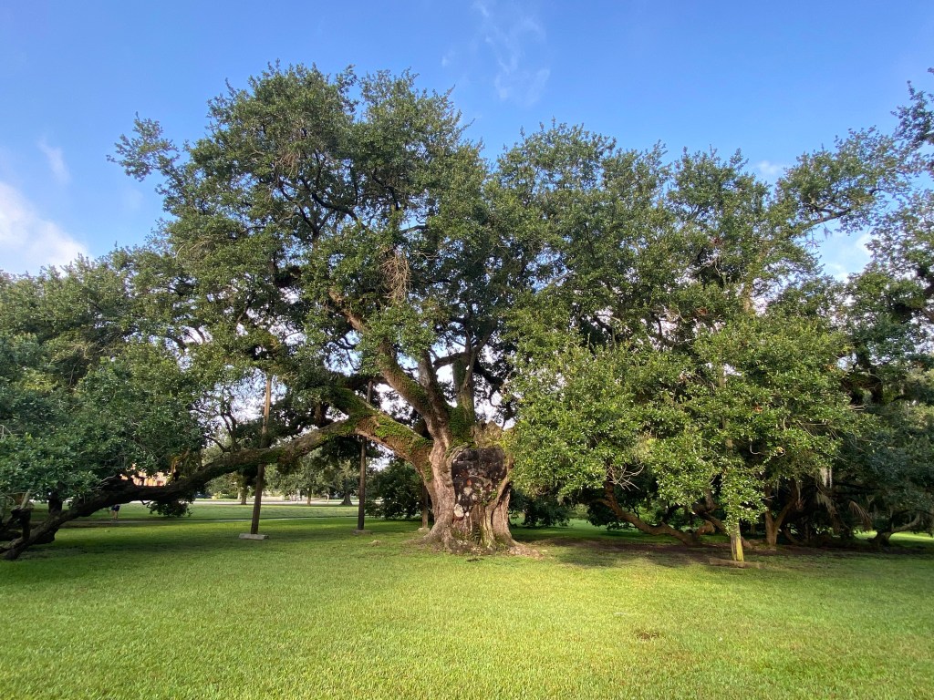
Just past the next intersecting sidewalk, you will notice a grand live oak on your right, its weary limbs supported by timber posts. Notice how the tree limbs have grown around the supporting posts. Step off the path for an up-close look at this great-grandfather of the oaks. You can see and touch the scars of age. Flat plates of crustose lichen grow on the trunk. Notice the massive roots which are partially visible above the ground. With a circumference of approximately 27.5 feet, this is the John McDonough Oak, believed to have been growing here since before Columbus bumped into this continent on his search for a water route to the East Indies. Return to the path and continue your walk.
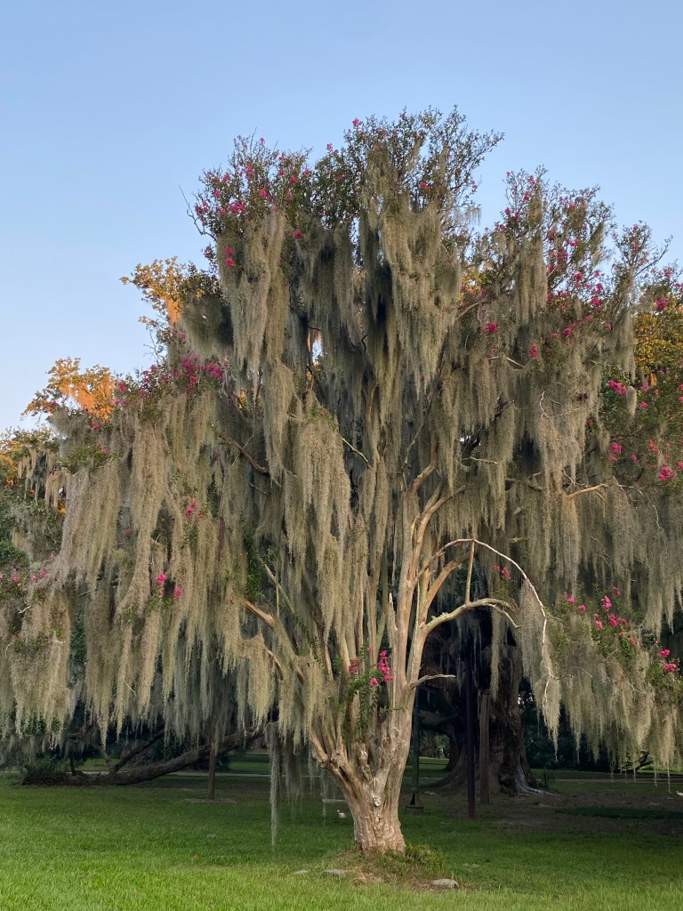
On your right is a crape myrtle tree (Lagerstroemia indica.) The grey, hairy-looking organizm almost completely covering the tree and blowing in the breeze is Spanish moss (Tillandsia usneoides). It is an epiphyte, absorbing moisture and nutrients from the air. It uses the tree’s limbs only for support. Tiny yellow flowers bloom at night and are pollinated by moths. It reproduces both by seed and by small pieces of moss that break off and are carried by wind or birds to another tree. Spanish moss, which is not a moss at all, is a bromeliad and related to the pineapple. You will also see Spanish moss growing on many of the live oaks.
A little farther up is an open lawn on your left. A plaque on the ground states that this is Colony Grove, a 1976 bicentennial planting of trees from the thirteen original colonies. Except for a few Southern magnolias (Magnolia grandiflora) and some young live oaks, the area is almost void of trees. Perhaps one of the oaks, the state tree of Georgia, was part of the original grove. Representative trees of the other colonies did not survive in the ecosystem of south Louisiana. Gardeners, is there a lesson to be learned here?
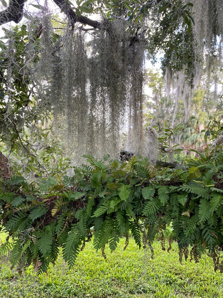
Continue along the path. If you are visiting after a recent rainfall, you will see green fern growing on the heavy limbs of many of the oaks. If you are visiting during a period of drought, the fern will be brown. This is Resurrection Fern (Pleopeltis polypodioides). It can dry out almost completely and curl up as if dead until rain restores it to its lush green state. Like Spanish moss, it does not harm the trees but uses them only for support. Resurrection fern, a green plant, makes its food through the process of photosynthesis; it also gets water and nutrients from the air. It reproduces by spores present on the underside of the leaves.
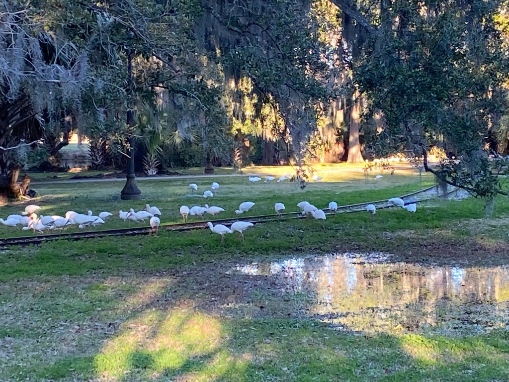
In the early morning or evening, you are likely to see yellow-crowned night herons (Nyctanassa violacea) foraging beneath the oaks and along the bayou. Flocks of white ibises (Eudocimus albus) also fly from the bayou and peck for tasty morsels beneath the oaks. What other animals do you see or hear?
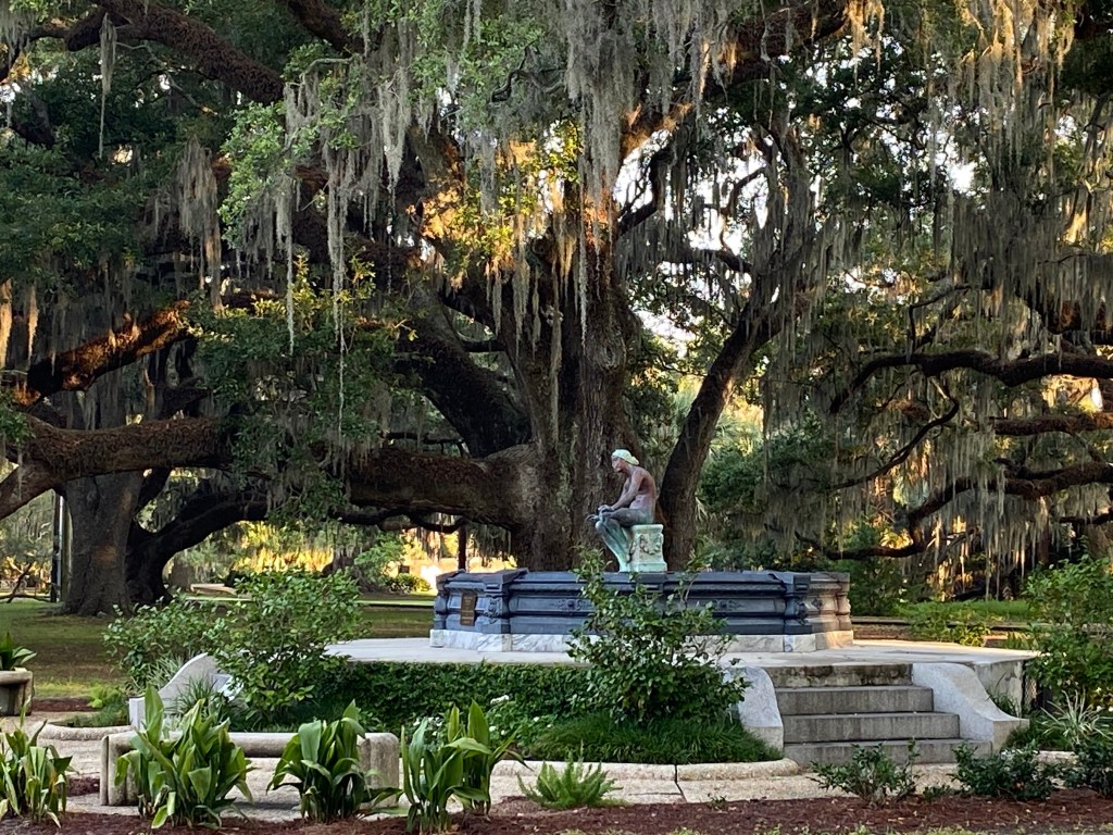
No longer a wild area, the Historic Oak Grove has been cultivated to invite people to enjoy the park. Man-made gardens and fountains are now part of the landscape. Take some time to sit quietly on one of the benches in the grove and enjoy your surroundings.
Up ahead on your left, is the south entrance to City Park at Anseman Avenue, formerly the park’s original entrance. The arched Pizatti Gate (1910), named after its donor, Salvatore Pizatti, invites visitors along City Park Avenue to enter. Walk through the entrance garden, cross Anseman Avenue, and continue along the pathway of the garden on the other side of the street. You will notice train tracks ahead on your right. The City Park train can be boarded in the Carousel Gardens amusement area of the park. The 15-minute ride carries you beneath the magnificent oaks, abound Bayou Metairie, over a bridge by the Sydney and Walda Besthoff Sculpture Garden, and through a tunnel back to the station.
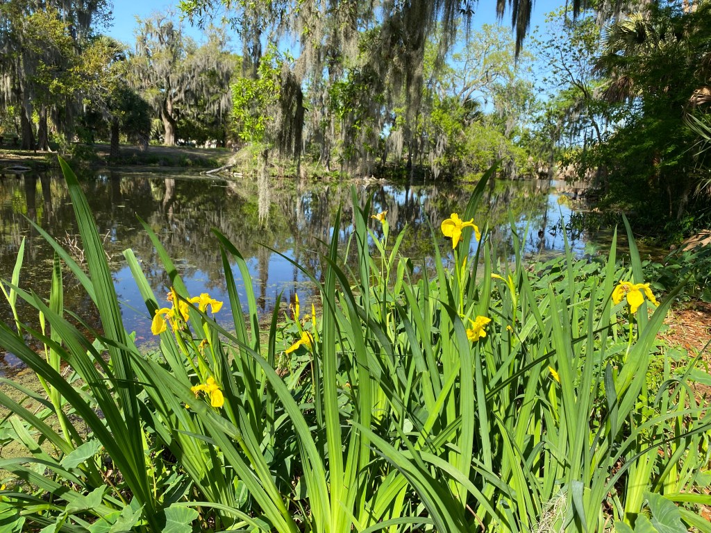
Cross the tracks and continue along the path that follows the bayou. You will notice some old and young live oaks on your left. In spring, native yellow Louisiana irises (Iris fulva) bloom along the bayou. Yellow flag iris (Iris pseudacorus) also grows here; it is invasive and can crowd out the native species. To tell the difference, rub the leaf between your finger and thumb. The native iris has a smooth, flat leaf, while on the invasive Yellow Flag leaf, you will feel a hard, raised center vein. Elephant ear plant (Colocasia esculenta) is another invasive plant found along the bayou’s banks.
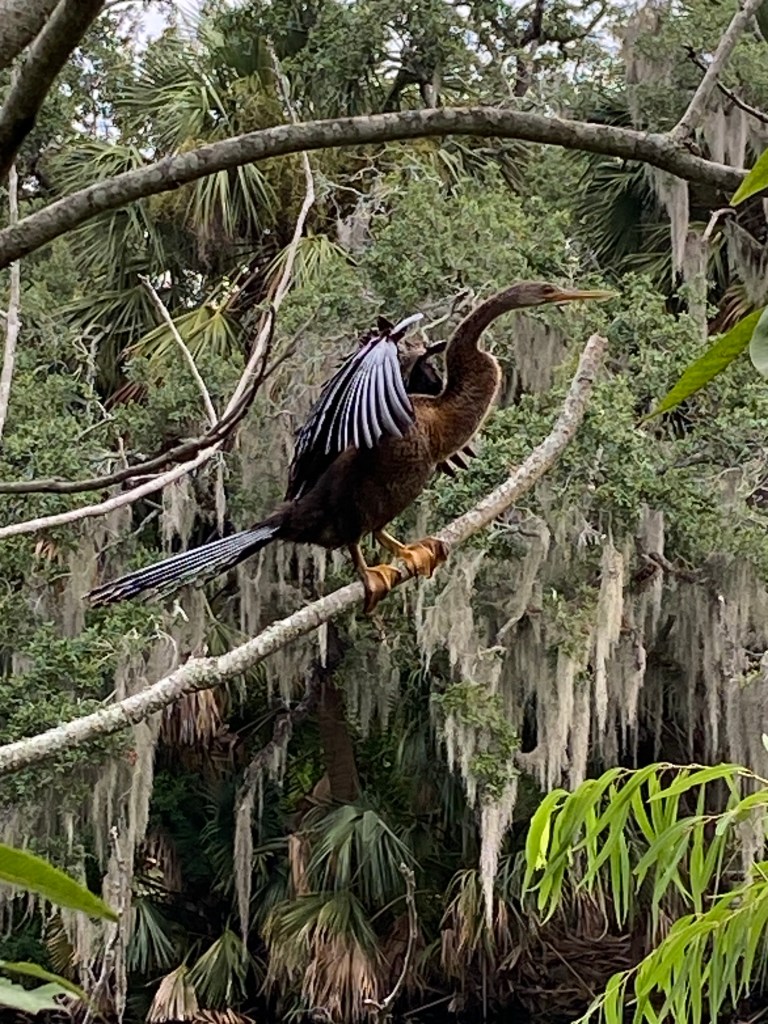
At the very end of the bayou, you will see a small island, with a sabal palm (Sabal palmetto), a small live oak, a cedar tree (Juniperus virginiana), and a bald cypress (Taxodium distichum), the state tree of Louisiana. All of these trees are probably “volunteers” whose seeds were carried here by water, wind or animals. Crammed so close together on the small island, they appear to be stressed. If you are lucky, you might see a majestic anhinga (Anhinga anhinga) perched on a branch, drying its wings in the sun.
Your walk ends where the bayou terminates at a wood and concrete outfall structure built by the WPA (1936-1937). The busy intersection in front of you, where Marconi Drive, City Park Avenue, and Orleans Avenue intersect, reminds you that you have been enjoying an urban green spot in the middle of a city. The modern building directly across Marconi Drive is a new addition to Delgado Community College (1921).
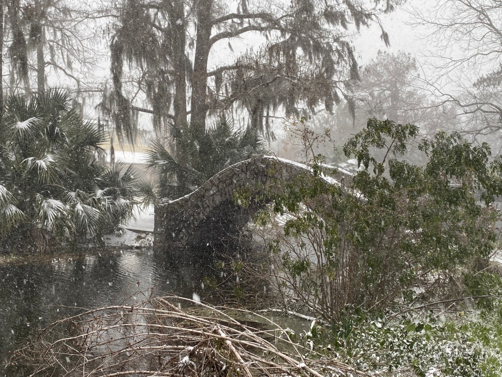
Bathrooms and refreshments are available at Cafe du Monde in the Timken center. To reach the Timken Center, turn around and follow this sidewalk, keeping the bayou close on your left. Cross Anseman Avenue and continue along the bayou until you come to the second stone, arched footbridge, the Angele Langles Bridge (1902). Cross the bridge and you will see Cafe du Monde.
If you prefer to return directly to your car or to the streetcar stop, simply retrace your steps back to the beginning or walk on the sidewalk along City Park Avenue to view the homes that face the park. Development of this neighborhood adjacent to the park was begun at the end of the nineteenth century.
Thank you to Lucy for her help and participation in this blog.
If you would like to tell me about your experience on this walk, please leave a comment.

Very, very nicely done, Kathy. I
LikeLike